Town Hall works:

We’re renewing the Service Centre entry at Glen Eira Town Hall. Weekday works from February to May will change how you enter the building. Follow onsite signage or read more here: Town Hall upgrades.

Published on 22 September 2025

Frankston Rail Trail improvements

We are improving and extending the trail to make it safer for everyone and easier for people walking and riding bikes to find their way.

Today, the Frankston Rail Trail runs from Glen Huntly to Bentleigh. It is mostly a paved path along the railway, shared between people walking and riding bikes.

We are delivering a range of improvements to the existing trail and calming traffic south of Bentleigh, creating a safer environment for everyone especially people walking and riding bikes.

This project is part of our Improving Paths, Connecting Communities program, jointly funded with the Australian Government through its Active Transport Fund.*

Once completed (over three stages, before 25 June 2029), the route will be:

  • safer for everyone whether driving, walking or riding bikes
  • easier for people to follow the route and get to local places
  • nicer for people walking and riding along the route.

Over the 2025–2026 financial year, we will complete the design for improving quality of the existing trail, deliver connections to local routes including new signs and ramps, and on-road extension to Patterson Road with speed cushions, signs and bike stencils on the roads.

Residents living near the locations where road constructions will take place will be notified ahead of the works.


Update 7 April 2026: We’re preparing to deliver a package of upgrades across several locations along the Frankston Trail and key connecting streets throughout Glen Eira, to improve safety and accessibility for everyone using the Trail. 

What’s happening?

We’re upgrading seven locations along the Frankston Rail Trail to support safer walking, cycling and driving, and help people of all ages and abilities move around their neighbourhood more comfortably. Works include new kerb ramps and speed humps, pavement markings, signage and minor surface improvements to make streets clearer and easier to navigate.

Site 1: Centre Road to Patterson Road, Bentleigh

Works will take place along Loranne Street, between Centre Road and Patterson Road, with a focus on improving safety and visibility for all road users. A flat top speed hump will be constructed outside 20 Loranne Street, supported by new signage, line marking and raised reflective pavement markers. Bicycle sharrows — shared-lane markings on the road that show the road is shared by cyclists and motorists — will also be installed along this section of the route to clearly identify the cycling connection and reinforce shared use of the street.

Site 2: Bentleigh Station to Nicholson Street (north of Centre Road)

Works will take place along Nicholson Street, near Bentleigh Station. A new kerb ramp will be constructed opposite to the 9, Nicholson Street, along with pavement markings and new signage for cyclists.  Some existing shared path markings on the road and outdated signage will be removed.

Site 3: Allnutt Park link — Fitzroy Street, McKinnon

Works will take place along Fitzroy Street, between Nicholson Street and Allnutt Park, with a focus to improve access and surface conditions along the trail connection. Works include the construction of new Bike ramp opposite to the 48A Wheatley Road, Pram ramp and a Bike ramp at the intersection of Fitzroy Street and Nicholson Street and the grouting of bluestone at both ends of the street to create a smoother surface. Additional bicycle sharrows — shared-lane markings on the road that show the road is shared by cyclists and motorists — and signage will be installed, with some existing signage removed, to improve wayfinding and support safer travel to and from Allnutt Park.

Site 4: McKinnon Station — McKinnon Road and Station Avenue

Works will take place along McKinnon Road and Station Avenue to improve route clarity for people cycling through the station precinct. Pavement markings, including a bicycle sharrow — shared-lane markings on the road that show the road is shared by cyclists and motorists — in Station Avenue, will be installed alongside new signage. These changes are intended to improve visibility of the cycling route and increase awareness among other road users in a busy local area.

Site 5: Joyce Park link — Hall Street to Murray Road, McKinnon

Works will take place along Hall Street to Murray Road, with a focus on improving accessibility and strengthening the cycling connection. A new bike ramp and a pram ramp will be constructed at the intersection of Hall Street and Walnut Street, with additional signage and bicycle sharrows — shared-lane markings on the road that show the road is shared by cyclists and motorists — installed along the route. One existing parking line at 57 Hall Street will be removed to better support safe movement and improve the function of the street as a trail link to Joyce Park.

Site 6: Carnegie Memorial Swimming Pool link — Wattle Avenue, Glen Huntly and Lyons Street, Carnegie

Works will take place along Wattle Avenue and Lyons Street. Bicycle sharrows — shared-lane markings on the road that show the road is shared by cyclists and motorists — and new signage will be installed to clearly mark the route and support safer access to this key community facility. These upgrades will help improve legibility of the trail connection for all road users.

Site 7: Station Place — near Watson Grove, Glen Huntly

Works will take place along Watson Grove, with a focus to improve accessibility and pedestrian safety. This includes the construction of a bike ramp and a pram ramps, and removal of an existing pram ramp at the intersection of Station Place and Watson Grove, and reconstruction of sections of kerb and nature strip. New signage will also be installed to support safer and more accessible movement through the area.

When is it happening? 

Works on Site 1 will be carried out at night from 8pm to 3:30am, between 20 April 2026 and 1 May 2026.

Works on all other sites will start on Monday 20 April and be completed by Monday 25 May, weather permitting. 

What are the impacts? 

Works will take place weekdays between 7.30am–4.30pm. There may be some noise and dust from the sites, but our contractors will do their best to minimise it.

There will be road closures or detours near 20 Loranne Street, 9 Nicholson Street and Fitzroy Street. There will also be traffic controllers and signage onsite to help you navigate through the work area safely. Some car spaces around each of the worksites may be temporarily unavailable and points throughout the works while the upgrades take place. 

Who to contact? 

If you have any questions or would like to speak to onsite staff, contact Pavel Aronovych from Prestige Paving Pty Ltd on 0488 790 778.

If you have any questions or need any assistance, contact Projects Engineer Sachini Rathnayaka on 9524 3333 or at srathnayaka@gleneira.vic.gov.au


There are four broad packages to the improvements 1. Improving quality of the existing trail from Station Place (Glen Huntly) to Centre Road (Bentleigh), with new lighting, trees, benches and ramps for getting on and off the shared use path 2.	Better connections to local routes, including to Carnegie Memorial Swimming Pool, Joyce Park and Elster Creek Trail, with new signs, bike stencils and ramps 3.	Clearer signs along the entire route, including directional and ‘share the road’ signs, as well as pavement markings 4.	On-road extension from Centre Road to South Road, along Lorrane Street, North Avenue and Railway Crescent, with raised pavements (speed cushions), bike stencils and signs.

* Our Improving Paths, Connecting Communities program supports delivering Council’s 2040 Community Vision, the Council Plan and the Integrated Transport Strategy 2018-2031 (2024 refresh). The program’s constituent projects are partly funded by Council as identified in Council Budget.

The Australian Government’s Active Transport Fund is providing $2.3 million to Glen Eira City Council to help improve shared use paths and footpaths, under our Improving Paths, Connecting Communities program. The program will make it safer, easier and nicer for people when they walk and ride bikes, including along the Frankston Rail Trail, between Queens Avenue and the Djerring Trail, and in centres such as Carnegie, Murrumbeena, Bentleigh and Moorabbin. Council is contributing at least $2.5 million to the program. The infrastructure improvements will be completed by 25 June 2029.

Related Articles

18 September 2023

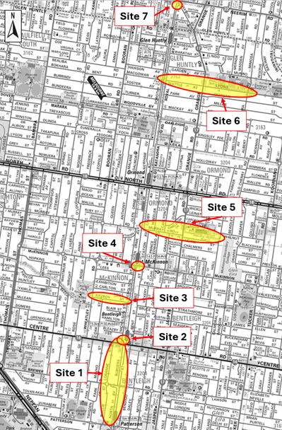
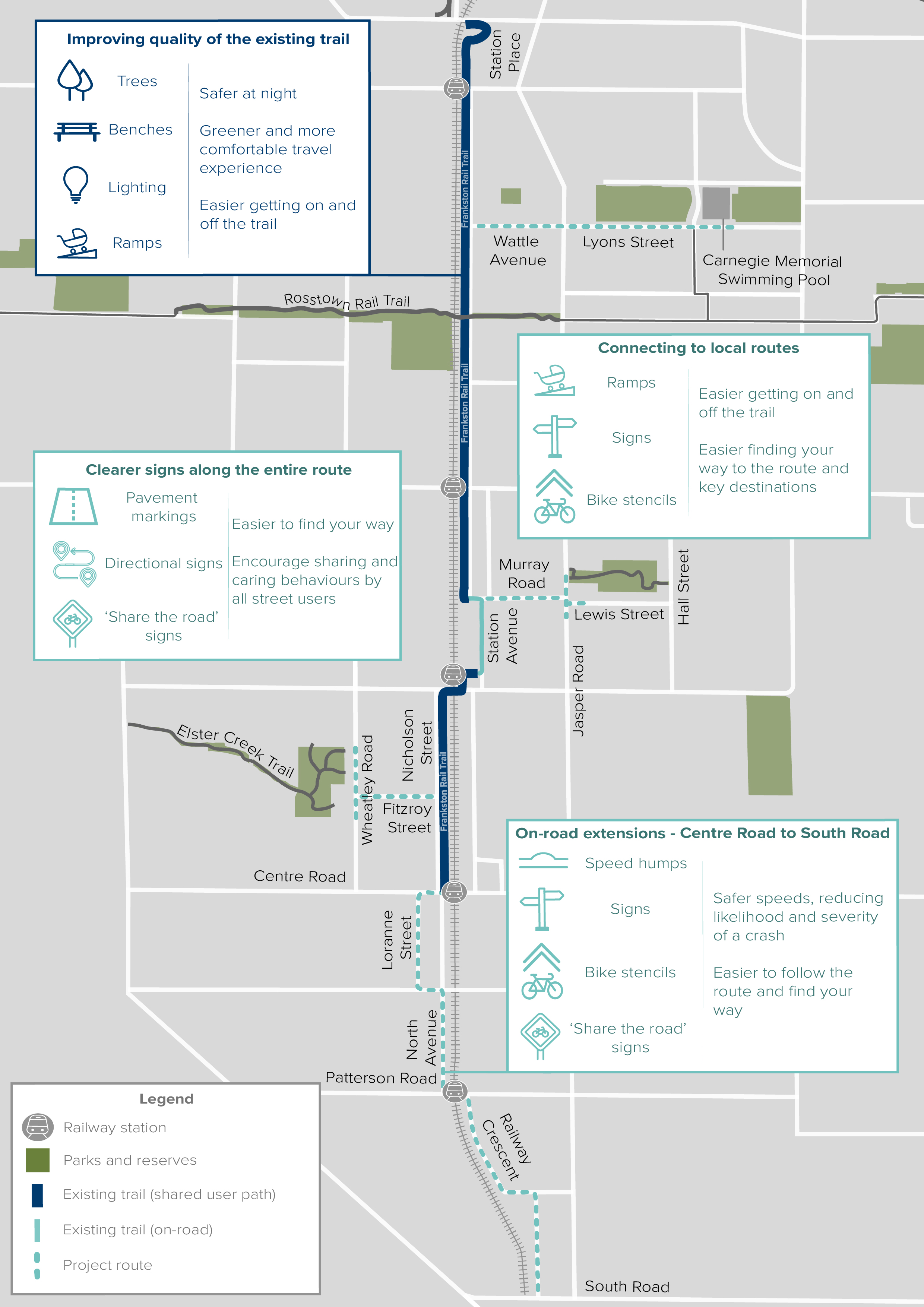
Rosstown Rail Trail improvements

We’ve been busy improving safety for users of the Rosstown Rail Trail, including updating signs along the 7.4-kilometre trail from Elsternwick to Hughesdale to help people stay on the track.